You are currently browsing the category archive for the ‘Thin places’ category.
Some thin places are fragile. I was planning on writing about the all-season delight of the mile-long walk on the Appalachian Trail Boardwalk off Glenwood Road in Vernon, across a flood plain and the suspension bridge over the Pochuck River. For years I have been walking that crooked path low through wetlands, over a river and back onto land.
That was before Hurricane Irene returned the flood plain into a form of the pre-historic lake it used to be. The boardwalk was made by volunteers over a seven-year period after 17 years of planning and acquiring the land. It was designed, smartly, to float up a bit during high water, but the waters of Irene were way too much and actually displaced the whole boardwalk. The New York-New Jersey Trail Conference is gathering people to help fix this and many of the natural trails in the region. You can help (nynjtc.org).
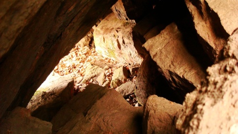
And some thin places endure. I’ve been visiting area rock shelters, natural caves where there is evidence of human use for thousands of years. Yes, I want to sit where they sat! “They” are bands of Delaware or Lenni-Lenape Indians… and who knows before that?
Just outside Florida, off Route 17A on Quarry Road at a “Protected Area” sign, the land rises to the famous Dutchess Quarry Caves, a huge cavern that has been dated back 12,000 years. Other shelters on the property were blown up years ago by the quarry owners. There are many smaller shelters around that have been dated to the Late Archaic period, about three to four thousand years ago.
One is in Warwick just off Brady Road and Magnolia Lane. Just before the first house on the right on Magnolia Lane, you can bushwhack up a small hill to “Mount Lookout,” the rocky outcroppings that form the shelter. Go find it and sit.
– Daniel Mack, Warwick
Share your thin places at dirt-mag.com.
 Somehow we find them. Places, landscapes, resting spots where just being there makes us feel different. These are called thin places, where the border between here and there, and now and then, gets dissolved.
One little jewel of a place is hiding right in the Village of Warwick. Lewis Woodlands is off Robin Brae Ave., which is off Rt. 94/Maple Ave. on the way to Florida. It used to be part of one of the big estates that’s been split up in the last century. These 14 acres hold beauty, mystery and wide history in the easy half mile loop of an old carriage path. Enter across a small field and a footbridge over Witch’s Brook, a clear, narrow finger of the Wawayanda creek. (Actually, all the small water bodies in the region were once just called the Wandering River. They all made their way to the Wallkill. This was confusing to the more literal-minded settlers, so they named and re-named each little branch as it if were distinct. Well, this is Witch’s Brook. The mayor of Warwick told me that when he was a boy playing in these woodlands there was an old woman living in a small house further up, and that’s really why it was Witch’s Brook.)
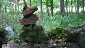
But that’s only the beginning. I took Tom Brannan, a local surveyor and archeologist, there a few years ago and he excitedly found what looked to me like just a pile of stones. He verified that this was a pile of stones created before the American Revolution by a British survey team mapping the colonies. But there’s more! Someone keeps making small cairns – balanced rock sculptures – along the path. Regulars in the woodlands claim to have never seen who it is, yet always the cairns are fixed and altered. Finally, there’s a craggy area with big boulders that features chert, that black mineral used to make primitive points and tools. This is a small but easy-to-visit quarry. Go see, feel for yourself.
And, any and every time you can, find the intersection of Brady Road and Bowen Road on the Warwick-New Jersey border. Oh, the stone walls, the dipping roads and views!
Daniel Mack, Warwick
Share your thin place in the comments here.
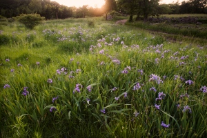
Thin places are places that feel different, where you can sense something else. It may be your own garden in the early morning or as the sun sets, or a lookout, a road, a special water feature, tree or rock that “says” something each time you see it. Here are a few of the thin places I know about, all within two miles of one another.
Route 94, the major route between Sussex and Orange counties, was also the major trail for the Lenape, the last Native Americans to live in this area. Off this road are some of the great thin places in the area. In Vernon at Maple Grange Park, on Maple Grange Road, is the now protected 40-acre Black Creek Site, a major Lenape Indian campsite. More than 15,000 artifacts, some dating back to 8,000 BC, have been found there. Sussex County Community College is doing archeological field work there this summer.
Near this camp, just down Canal Road off Maple Grange Road, are several chert quarries on the Appalachian Trail. Chert is a stone used for making tools and projectile points. You can recognize it by the way it’s found sandwiched in layers with other rocks. Most of the chert I’ve seen around here is black, though it can be white, grey or even red.
High Breeze Farm on Barrett Road, off Route 94 at the Vernon-Warwick border, is a triple delight. It is the closest you can get to what a 19th century farm looked like because it was operated as one by Luther Barrett until 1986. Secondly, it is a living museum of Lenape artifacts and there’s a little pull-off on Barrett Road just above the farm, where you are treated to a wondrous view of the mountains north and west of here.
– Daniel Mack, Warwick
Dan invites you to share your thin place in the comments here.

